
nCa Report
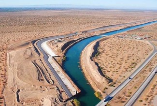
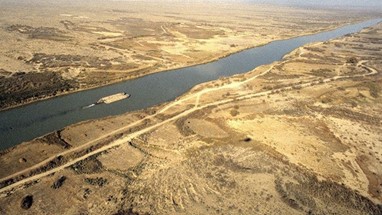
Karakum Canal, also known as the Turkmen River, is one of the longest manmade canals in the world. Fed by the Amu Darya River, it is the lifeline of the economy of Turkmenistan.
With the rising stress on the water resources, Turkmenistan, like the other countries in Central Asia, is scrambling to make the best use of available water.
In the first part of this report, we are reproducing an excellent article, written by Vladimir KOMAROV. It was published by the Turkmenistan magazine in its issue N9-10-2021.
In addition to providing some valuable information about the Karakum Canal, the purpose of including his article is to pay tribute to Komarov.
He passed away in January 2023 at the age of 78. In his obituary, we wrote: “He was Gold Standard in journalism. A story with byline of Vladimir Komarov was never in need of fact checking.”
He was a versatile writer and accomplished photographer. He was the recipient of the the title ‘Honoured Journalist of Turkmenistan’ in 2015. He was also the laureate of the Presidential Prize “Turkmeniň Altyn Asyry”, as well as the winner of numerous photo contests.
In the later part of this report, we will briefly look at the economic potential of the Karakum Canal beyond its obvious use as the source of irrigation water and fishing.
The River that Transformed the Karakum Desert
Vladimir KOMAROV
There is a truly unique hydraulic structure in Turkmenistan, unparalleled in the international construction practice.
The Karakum River was undoubtedly a grandiose construction site of the twentieth century, with its artificial canal stretching for 1,100 kilometers from East to West. Created by the labor and genius of the people, the irrigation system fundamentally influenced all forms of the economic, social and cultural life of Turkmenistan.
Combining the Amu Darya, the Murgab and the Kopetdag springs into a single water management system, the Karakum-derya, as the Turkmens call it, saved three large oases from the shortage of water and breathed new life into a million hectares of irrigated land. The fate of the majority of inhabitants of the country is either way connected with the Karakum River. It not only transformed the desert but also the life of the whole generation.
Turkmenistan is one of the oldest regions of irrigated agriculture. Even at the dawn of human culture, large irrigation facilities of that time were built there. Nowhere do people value water as much as in Turkmenistan. “It is not soil but water that gives birth,” the Turkmen folk wisdom says, but water was scarce. Nature endowed Turkmenistan with fertile lands with usury. Hundreds of thousands of hectares of virgin land lay deserted and barren under the burning sun. The Central Asian largest river, Amu Darya, was separated from these lands by one of the greatest deserts. The Turkmen people cherished for centuries a dream of using water of the Amu Darya for irrigation of waterless and dry lands. This dream, like a relay baton, was passed down from generation to generation.
Back in the early eighteenth century, the noble Mangyshlak Turkmen, Khodzha Nepes, on instructions of the elders of the Turkmen tribes, made his way through Astrakhan to St. Petersburg and turned to Peter I with a request to help the Turkmens make this dream come true. He told Peter I that the Amu Darya used to flow into the Caspian Sea, but then it changed its course. The envoy of the Turkmen tribes assured the tsar that the Turkmens would help “turn the river” if he, the tsar, took the people living there under his protection. The tempting prospect of turning the course of the Amu Darya along the old bed and subordinating new areas to its influence forced Peter I to organize a Caspian expedition, which the tsar specifically instructed to “search for the former riverbed” and look for the possibility of turning it into the Caspian Sea.
This expedition kicked off a series of explorations and research of the ancient bed of the Amu Darya that continued until the twentieth century. Many other expeditions were organized later. They were led by the prominent specialists – military engineers, hydrographs, geographers, topographers, geologists, agronomists. The famous Russian geographer and climatologist, Alexander Voeikov, wrote in 1912 that “the project of irrigating a vast area, including the Merv oasis, with the waters of the Amu Darya can become one of the most important enterprises of such kind in the world.”
The ideas of this and other scientists engaged in solving the problem of irrigating new lands and changing the “irrigation geography” were put into practice during the construction of the Karakum Canal, a grandiose facility of our time.
Several options for diverting the waters of the Amu Darya to the southwestern regions of Turkmenistan, including through the southeastern part of the Karakum desert were developed and proposed on the basis of the materials collected by the scientists. In particular, there were projects on partial shifting of the water flow of the Amudarya River known as the Kelif-Karakum variant, the Unguz variant, the variants by Alexander Glukhovsky, Georgy Sazonov, Methodius Ermolaev, Fyodor Morgunenkov, Georgy Rizenkampf, Ivan Boltenkov. Later, all these variants laid the foundation for drawing up a project on development of the country’s irrigation economy and, therefore, they were of great importance for all subsequent work. This is evidenced by ample material stored in the archives of Ashgabat, Moscow, St. Petersburg and Tashkent.
Due to the lack of water in the southern and southwestern parts of the country, the issue of the practical diverting of the Amu Darya waters increasingly required a solution. Owing to the extreme scarcity of local water resources in the area allocated for construction of the water canal, only 166,000 out of 4.4 million hectares suitable for irrigation, or 3.8 percent of all areas, were irrigated before the start of construction. Water supply in some areas reached 30 percent instead of 90 percent required by the standard.
In the end, it was decided to build a canal along the highway, crossing the basins of the Murgab and Tejen rivers, the vast Kopetdag plain, which had great prospects for further development.
According to scientists, construction of the Karakum Canal through the sands of the South-Eastern Karakum desert to the low-water areas of the Mary and Tejen oases and further to the west along the Kopetdag should have comprehensively solved a number of national economic problems, such as the problem of irrigation water and development of large areas of vacant land, expansion of agricultural production, water supply, development of recreation areas and suburban agricultural base around settlements, watering of pastures, development of fisheries and waterways.
The construction project of the Karakum Canal was an outstanding effort of a large team of the design institute “Turkmengiprovodhoz.” In addition, 17 other design and survey and 18 research institutes of the country were involved in the design, subcontracting and contractual work. When designing the Karakum Canal, specialists scrupulously considered every aspect that could have a negative impact on the surrounding nature.
The economic side of construction also had to be taken into account. First of all, it was important to choose the right water intake from the Amu Darya, given the variability of its channel, water turbidity and other specifics. A “multi-head water intake” scheme with a lake sedimentation tank was proposed and built for the first time ever. This ensured great savings in the construction and operation of the hydraulic structure.
Specialists established the canal’s altitude position so that it could operate and supply a large amount of water without building a dam on the Amu Darya, without pumping water from the river to the canal by a pumping station, remain in an earthen bed and self-flowing with bottom depressions at every kilometer of the route. Finally, it was necessary to protect the canal from sand drifts. All these issues had to be solved with sufficient accuracy and reliability, which was of particular importance owing to the assumptions made by some scientists that it was impossible to build a canal through the sands because of large losses.
Particular importance was given to the organization and methods of construction in a sandy, completely impassable desert with no settlements and no international experience of building such hydrotechnical facilities. The success of the entire construction campaign was above all inextricably dependent on the construction of the first stage of the Amu Darya – Murgab that took place in the most difficult conditions of the South-Eastern Karakum desert. The design of this section was completed in 1951 by “Karakumvodproekt”, and the construction of the facility began in 1954.
“Glavkarakumstroy” department was established to oversee the construction work. Over the time of construction of the artificial river, it turned into a powerful modern construction organization with 110 divisions and a team of twenty-two thousand people. This department was assigned a wide range of works, including the construction of the canal along with its hydraulic structures, bridges, pumping stations and reservoirs, development of virgin lands in the canal area and reclamation of irrigated lands.
The scale of construction was huge.
At the first stage of the canal construction, builders had to move 54 million cubic meters of earth, lay 42 thousand cubic meters of concrete and reinforced concrete, erect one and a half thousand tons of metal structures. This stretch of 400 kilometers became a real standard and a huge natural laboratory, where most engineering solutions and results of scientific research were developed and tested with sufficient reliability. It also formed the basis for the design and construction of all subsequent three stages of the man-made river.
Construction of the river bed was carried out at an accelerated pace despite the fact that right from the start builders faced great problems relating to uninterrupted supply of food and industrial goods, as well as drinking and industrial water. If we take into account the summer heat, when the sand heats up to 80 degrees, and frequent dust storms, one can imagine the hardships.
The most time-consuming and crucial was the canal construction in the so-called Obruchevskaya steppe, known for its complex terrain and 20–25 meters high sand dunes. In some areas, one had to dig a pioneer trench with scrapers and bulldozers to let water through, and then run dredgers along it.
In other areas, the river bed was developed mainly by the energy of flow supported by hydraulic erosion. This method also allowed builders to lead water flows in the right direction, ensure water supply for industrial and domestic needs in the desert and the possibility of using water transport and hydromechanization of earthworks. Specialists used the energy of peaceful explosion for construction purposes, which four times reduced the cost of labor, time and mechanisms. They also learned how to use dune sand for production of concrete.
In 1959, the Amu Darya water, having passed a 400-kilometer path, 300 kilometers of which lay in an impenetrable sandy desert, came to the Murgab oasis. After hundreds of thousands of years, the Karakum Canal again connected the Amu Darya with the Murgab. Indeed, as scientists believed, the Amu Darya flowed towards the Caspian Sea in ancient times. Murgab and Tejen were the tributaries of the river. This way, they formed a single river system. Then, the Amu Darya turned to the Aral Sea. By the will of scientists and specialists, this trio was again united into a single ring water supply system.
In the first year of operation, the Karakum Canal provided “emergency assistance” to rural workers. That year, 157,000 newly developed and old irrigated lands were watered by an artificial river in the Murgab oasis.
In 1961, the second stage of the Murgab – Tejen canal was completed. Other than extending the canal from the Murgab river to the Tejen river, the project envisaged the construction of the Khauzkhan reservoir with the capacity of 435 million cubic meters of water and a number of hydraulic structures. Collective farms, industrial and construction organizations, ministries and departments provided all possible support in terms of labor-force, earth-moving equipment and transport. At the nationwide construction site, builders had to complete 33 million cubic meters of earthworks, 16 000 cubic meters of concrete and reinforced concrete works and 266 000 cubic meters of stone work in a short time.
The work began in April 1962. Modern equipment, highly qualified specialists with experience of construction of the first stage and invaluable help of villagers and collectives of industrial enterprises made it possible to complete the construction in seven months. The pace of construction was unprecedented for the international practice of hydraulic construction! Similar to the first stage, people of more than thirty nationalities of the country took part in the construction. More than 700 builders were awarded high state decorations. Bulldozer operator Bidty Yazmukhammedov and excavator operator Tachmurad Byashimov were awarded the title of Hero of Socialist Labor for their feats of labor.
The threat of drought in Tejen was gone forever.
The man-made river breathed life into the second large oasis of Turkmenistan, producing priceless fine-stapled cotton. The water supply made it possible to develop 72 000 hectares of land (27 000 of them in the first year of operation). Starting from the first years of supplying life-giving water to the oases, the artificial river ensured an increase in cotton production from year to year.
In November 1961, the newly built Khauzkhan reservoir started receiving water, and the Amudarya water came to Ashgabat through the pioneer trench in 1962. This 256-kilometer long trench of the third stage was completed in 9 months despite difficult soils with stone and gravel sections!
The author of these lines remembers very well that hot day of May. We, a few secondary school pupils, were running along a dusty country road and probably would have missed this historical moment if it was not for the driver of an old truck, who took pity on us and slowed down so that we could jump into the back of his truck. So, we were in time for that solemn moment when an excavator broke the earthen bridge and the Amu Darya water rushed into the canal and ran along the sandy bottom. Here it was – a river in the desert! Thousands of Ashgabad residents stood and sat on the earthen dumps!
No words, no comparisons can convey that joy on people’s faces! Old men, women, children – all rushed to the long-awaited precious water to touch it. People wept tears of joy. Most residents of the capital and surrounding villages had never seen so much water in their lives! There were only one swimming pool in Ashgabat and two mountain rivers in the gorges of the Kopetdag. Wells drilled in the city were the main source of water supply, the flow rate of which was constantly declining. The city lived on a “starvation water ration”, as water was distributed according to a schedule. Collective farms adjacent to Ashgabat also did not have the opportunity to produce vegetables and other crops. A year later, outside the city, among the dunes, the Eastern (Sportivny) and Western (Kurtlinskoye) reservoirs were already filled with water, whose sandy beaches provided a resting place for the Ashgabat residents.
***
The economic potential of Karakum Canal
The irrigation system of Turkmenistan is dependent almost entirely on the Karakum Canal. It is also the primary source of freshwater fish in Turkmenistan.
However, with the new and emerging technologies, it is possible to explore some other economic benefits of the Karakum Canal.
Power Generation – One of the areas to explore is the possibility of power generation from the rather fast-moving waters of the Canal. This can be done without disturbing the flow of the Canal. — Here is a quote from the website of the Union of Concerned Scientists that sheds some light on this potential: Hydropower can also be generated without a dam, through a process known as run-of-the-river. In this case, the volume and speed of water is not augmented by a dam. Instead, a run-of-river project spins the turbine blades by capturing the kinetic energy of the moving water in the river. Hydropower projects that have dams can control when electricity is generated because the dams can control the timing and flow of the water reaching the turbines. Therefore these projects can choose to generate power when it is most needed and most valuable to the grid. Because run-of-river projects do not store water behind dams, they have much less ability to control the amount and timing of when electricity is generated.
Profitable de-silting – is a rather broad area of the economic potential of the Karakum Canal. A systematic approach can yield the following from the scientific dredging of the Canal:
- Salts and minerals: There are a number of natural and industrial salts and minerals in the waters of the Amu Darya River, the river that branches out as the Karakum Canal. These include sodium, potassium, calcium, and magnesium compounds. In some areas, particularly downstream and in drainage basins, salt concentrations increase.
- Gold: It may sound rather far fetched but historically there have been the reports of the alluvial gold deposits in certain sections of the river and some percentage could possibly be mixed in the waters running through the Karakum Canal.
- Sand and gravel: The bulk of the de-silted mud could be a good source for the construction sand and gravel.
Transportation – Nearly half of the length (about 450km) is navigable by boats and tugs. After proper de-silting, it should be possible to navigate the entire length of the Canal. This can be a cheap and effective source of transportation of passengers and cargo.
Tourism and recreation – With the de-silting of the Canal and the expansion of its transportation potential, there arises the lucrative scope for an entire branch of the tourism and entertainment industry. There can be the Canal cruises, there can be the fishing expeditions and there can certainly be the uniquely soothing stay on a House Boat. The possibilities are vast. The profit potential is high.
Aquaculture – Aquaculture on the strength of the Karakum Canal is already taking roots. In addition to some profitable species of fish, there are private farms engaged in the cultivation of the freshwater shrimps. This can be expanded in the public-private partnership format, bringing in the foreign partners who specialize in these areas. /// nCa, 31 March 2025 (image credits TDH, Daryo.uz, Ayan Travel)


Leave a Reply